
One word on a map
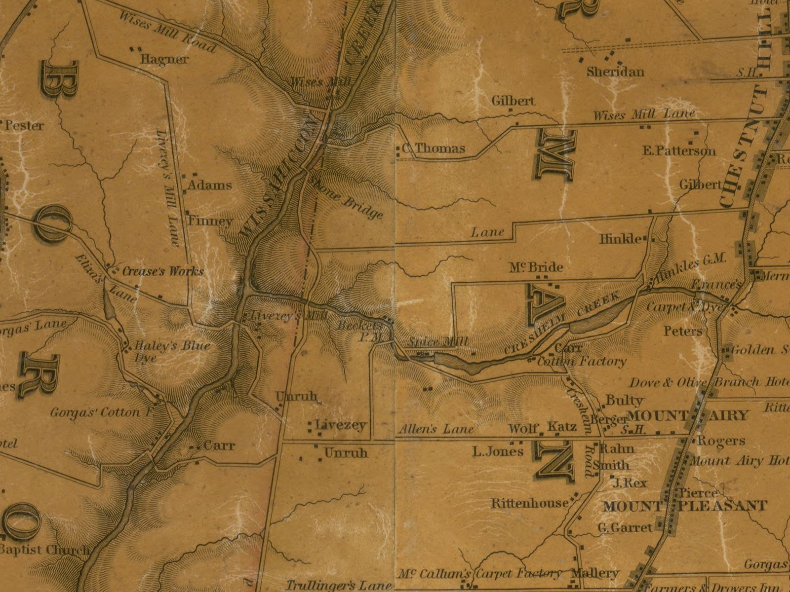
This mill’s whole record is two words long. On Charles Ellet Jr.’s map of Philadelphia County, drawn in 1843, the words “Spice Mill” are printed along Cresheim Creek — the busiest mill tributary of the Wissahickon, running down to the main creek through Germantown and Chestnut Hill. Read in order from the creek’s mouth upward, the map’s mill row runs: Bechtel’s Paper Mill, then the Spice Mill, then Carr’s Cotton Factory, then France’s carpet and dye works, then Hinkle’s grist mill. So the seat stood on Cresheim Creek between the lower Bechtel paper mill and Carr’s mill, in the lower half of that crowded row of works.
That is the whole of its fixing, and this account will not dress it up as more. No deed read names this mill. No directory, survey, or second map read names it. No dam or race of its is described anywhere. Nothing standing on the ground today is attributed to it in any source read. A mapmaker in 1843 thought the works worth two words, and two words are what survive.
The name the index gave it
The seat does carry a fuller name — but the name comes from a card index, not from the creek. The Free Library of Philadelphia built a subject index to Ellet’s map, the scholarly apparatus on which later lists of the valley’s mills rest, and its heading for this seat reads “Werkel & Smith Spice Co.” The same cataloguing tradition also carries the variant “Weikel & Smith Spice Co.” It is from that index heading that this mill takes the name it is usually listed under.
The two spellings are not a small slip. The firm itself spelled its name one way, and the index another, and the difference matters to what follows — because the name, examined closely, does not fit the map at all.
A real firm, twenty-four years too late
The firm is real, and it can be documented entirely away from the creek. About 1880 the Weikel & Smith Spice Co. of Philadelphia was issuing trade cards — one survives in Michigan State University’s Sliker Collection — promising that “the best and purest spices are those manufactured by the Weikel & Smith Spice Co., Philadelphia, Pa.” In 1876 the firm exhibited at the Centennial Exhibition in Philadelphia; the official catalogue lists “Weikel & Smith Spice Co., Philadelphia, Pa. — Mustard, spices, celery-salt, blacking.” (The catalogue’s own text misrenders the name once as “Werkel” — the same wobble the index card shows.) In 1893 a Weikel & Smith token was struck for the World’s Columbian Exposition. A modern dealer’s research note on a surviving spice tin — sales copy, and graded as nothing more — traces the firm to a founding in 1850 as Hummel, Bohler & Co., reorganised under the Weikel & Smith name in 1867.
Now set those dates against the map. If the Weikel & Smith name dates to 1867, the firm under that name cannot be the operator Ellet mapped in 1843 — it is twenty-four years too young. Every dated trace of the firm found is later still: the Centennial exhibit of 1876, the trade cards of about 1880, the token of 1893. No trace of the firm under either of its names was found dated before the 1870s.
The conclusion is plain, and it is this mill’s real story. The index heading is not a period label. Someone indexing the map in the twentieth century reached for the best-known Philadelphia spice firm’s name and attached it to the map’s anonymous “Spice Mill.” Whether that firm — or its Hummel, Bohler predecessor — ever actually ground spice on Cresheim Creek is a separate question, and nothing read answers it: no directory line, no advertisement, no record of any kind ties any spice firm to this seat in any year. Who ran the Spice Mill in 1843 is unknown. Any account that prints “Werkel & Smith’s spice mill ground spices on Cresheim Creek in 1843” would be printing a cataloguer’s guess as a fact.
What is not known
Almost everything else about this seat is silence, and the silence is printed here rather than filled. There is no chain of owners to give. What the mill ground, what stones it turned, what power it drew beyond the creek itself, and at what scale it worked are described in nothing read. Its end is unrecorded: the seat does not appear on the later county maps read for this collection — Barnes’s map of 1855 and Smedley’s of 1862, as swept, do not carry it — so its disappearance is a gap, not an event. One open question stands next door: whether this seat and Patterson’s flour mill, described as “just above” the lower Bechtel mill, could be the same ground at different dates. Nothing read joins them, and they are kept apart here.
The seat’s one picture is the map itself. A public-domain detail of Ellet’s 1843 map shows the printed words “Spice Mill” at the seat’s place on the creek — an image of the seat, honestly captioned as a map label, not a picture of any building. No image of the mill itself exists in any source read. One caution travels with that picture: the same map prints a second “Spice Mill” label far away on the Monoshone, the creek at RittenhouseTown. That label belongs to no mill in this collection, and it is not this one.
Timeline
| 1843 | Ellet’s map of Philadelphia County prints “Spice Mill” on Cresheim Creek, between Bechtel’s Paper Mill and Carr’s Cotton Factory; the operator is not named. |
| 1850 | The firm later called Weikel & Smith is said to have been founded as Hummel, Bohler & Co. (a modern dealer’s research note; unverified against a period source). |
| 1855 | Barnes’s map of the county, as read, does not carry the seat. |
| 1862 | Smedley’s map, as read, likewise does not carry it. |
| 1867 | The firm is said to have been reorganised under the Weikel & Smith name (same dealer’s note; unverified) — twenty-four years after the map. |
| 1876 | Weikel & Smith Spice Co. exhibits at the Centennial Exhibition in Philadelphia: mustard, spices, celery-salt, blacking. |
| c. 1880 | The firm issues trade cards in Philadelphia (“Choice Bohsemeem”). |
| 1893 | A Weikel & Smith Spice Co. token is struck for the World’s Columbian Exposition (catalogued as Eglit 555). |