
Haley’s Dye Works stood in Roxborough, on Gorgas Lane east of Ridge Road (Ridge Avenue), adjoining the Gorgas mill seat. Gorgas Lane leaves the avenue just above Levering’s Lane — today’s Leverington Avenue — and runs east and down to Wissahickon Creek. The dye works stood somewhere on that slope. Which water it used, no source read for this story says: the creek at the foot of the lane, or Oil Mill Run, which Brandt’s 1927 history of the valley shows running beside the lane and crossing it. Dyeing is a thirsty trade that needs little power, and either water would have served it.
No picture of the works survives. No photograph, no survey drawing, and no sketch of its buildings was found in anything read. What survives is a name on maps — three of them — and this short account is the whole of it.
Three maps
The index to Ellet’s map of the county, printed in 1843, lists “Haley’s Dye Works: Gorgas Lane east of Ridge Road.” The index to Sidney’s map of 1847 repeats the words exactly. The index to Barnes’s map of 1855 puts the same works at “Wissahickon Creek above Levering’s Lane” — the very words it uses for “Gorgas’ Factory,” the mill next door. The two descriptions are one place seen from two ends: the lane from the ridge, the creek from below.
On Ellet’s map itself, the printed label at the works reads “Haley’s Blue Dye.”
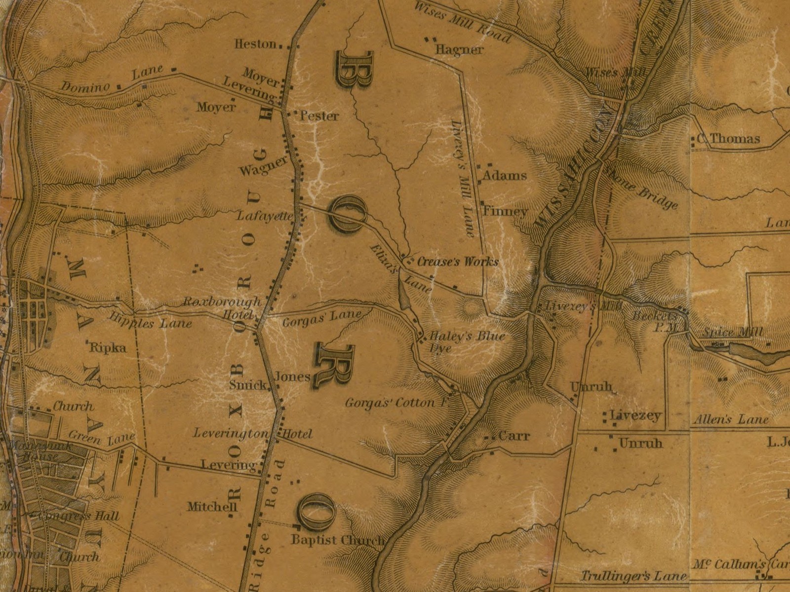
However small the works was, it stood in short company. Ellet’s map names only three textile works in the whole of Roxborough township: the Gorgas Cotton Factory, Haley’s Dye Works, and Rees’ Print Works on Eliza’s Lane. Haley’s was one of the township’s three named manufactories of 1843.
The work
The works dyed cloth. Dyeing is the middle step of cloth making: the cloth is woven first, then dyed, then finished and printed. The Gorgas Cotton Factory made cloth at the creek, and Haley’s dyed it — if the two worked together. Whether they did is a guess drawn from the map, not a fact from any record, and it is printed here as a guess.
Of the works itself, nothing more is known. No record read gives its size, its buildings, its power, or the name of a single person who worked in it.
A name with no one behind it
No owner or operator of Haley’s Dye Works is named in anything read. The dyer’s first name was never found, and neither were his dates. Searches for the works by name turned up only the map indexes themselves, and one sentence in the Ridge Avenue historic district nomination that repeats them. No directory line, no census return, no insurance survey, no sale notice, and no newspaper item for a Haley dye works on this creek was found in anything read.
The sister project on this site, which writes the lives of the valley’s people, struck “Haley” from its own list for exactly that reason: a life cannot be written from a name on maps. The seat stays, because three maps document it. The man does not, because no record found names him.
An open question
Dyeing did not leave Gorgas Lane when Haley’s name left the maps. The firm of Carmany & Boone worked a dye works on the lane, near the creek, from at least 1880 to 1887. The project files place that firm at the Gorgas factory seat. If it stood here instead — on Haley’s ground — then this dye works had a later life under another name. No source read decides the question, and this account does not pretend to. It is printed here so that a future record can settle it.
The end
The works is present on the maps of 1843, 1847, and 1855, and absent from the index to the city atlas of 1862, which names other Roxborough works — Crease’s Chemical Works on Eliza’s Lane among them — and no Haley. That is one index’s silence, and indexes leave things out; it is printed as a bounded negative, not as proof of an ending. No fire, no sale, no taking, and no demolition of the works was found in anything read.
Some records that might say more sit beyond this project’s reach, because it works from the online record alone: the census of manufactures for the 21st Ward in 1850 and 1860, where a return for this works would sit if one was made; the Roxborough deed books; and Macfarlan’s 1949 typescript on the valley’s mills, kept on paper in the Free Library’s Map Room. None of them could be read online. They stand here as named gaps.
Today the lane still runs from Ridge Avenue down to the creek, and nothing on it names the dye works. It survives where it always survived: on the maps.
Timeline
| Year | Event | Source |
|---|---|---|
| 1843 | Ellet’s map index names “Haley’s Dye Works: Gorgas Lane east of Ridge Road”; the map itself labels the works “Haley’s Blue Dye” | Free Library index and map face, Ellet (1843) |
| 1847 | Sidney’s map index repeats the siting, word for word | Free Library index, Sidney (1847) |
| 1855 | Barnes’s index places the works at “Wissahickon Creek above Levering’s Lane” | Free Library index, Barnes (1855) |
| 1862 | The works is absent from the city atlas index, which names other Roxborough works | Atlas of the City of Philadelphia (1862), Section 20 index |
| 1880–1887 | Carmany & Boone work a dye works on Gorgas Lane near the creek — at this seat or the Gorgas factory seat, no source read decides | Camden history of John H. Carmany |