The Gorgas mill seat stood on Wissahickon Creek in Roxborough, at the foot of Gorgas Lane, just below Livezey’s mill at Glen Fern. Two mills worked on the seat: a water grist mill, which grinds grain into meal and flour, and an oil mill, which pressed oil from seed.
The Gorgas name needs care on this creek, because it sits on three different grounds. This seat is not the Monastery mill seat on Kitchen’s Lane, two miles up the creek, though the same family opens both stories. And it is not Gorgas Park, on Ridge Avenue at Hermitage Street — the Joseph Gorgas homestead tract, no mill of this seat’s kind on it; the park is not this mill’s ground, and no evidence for it. The surname alone fixes nothing here. The records fix this seat.
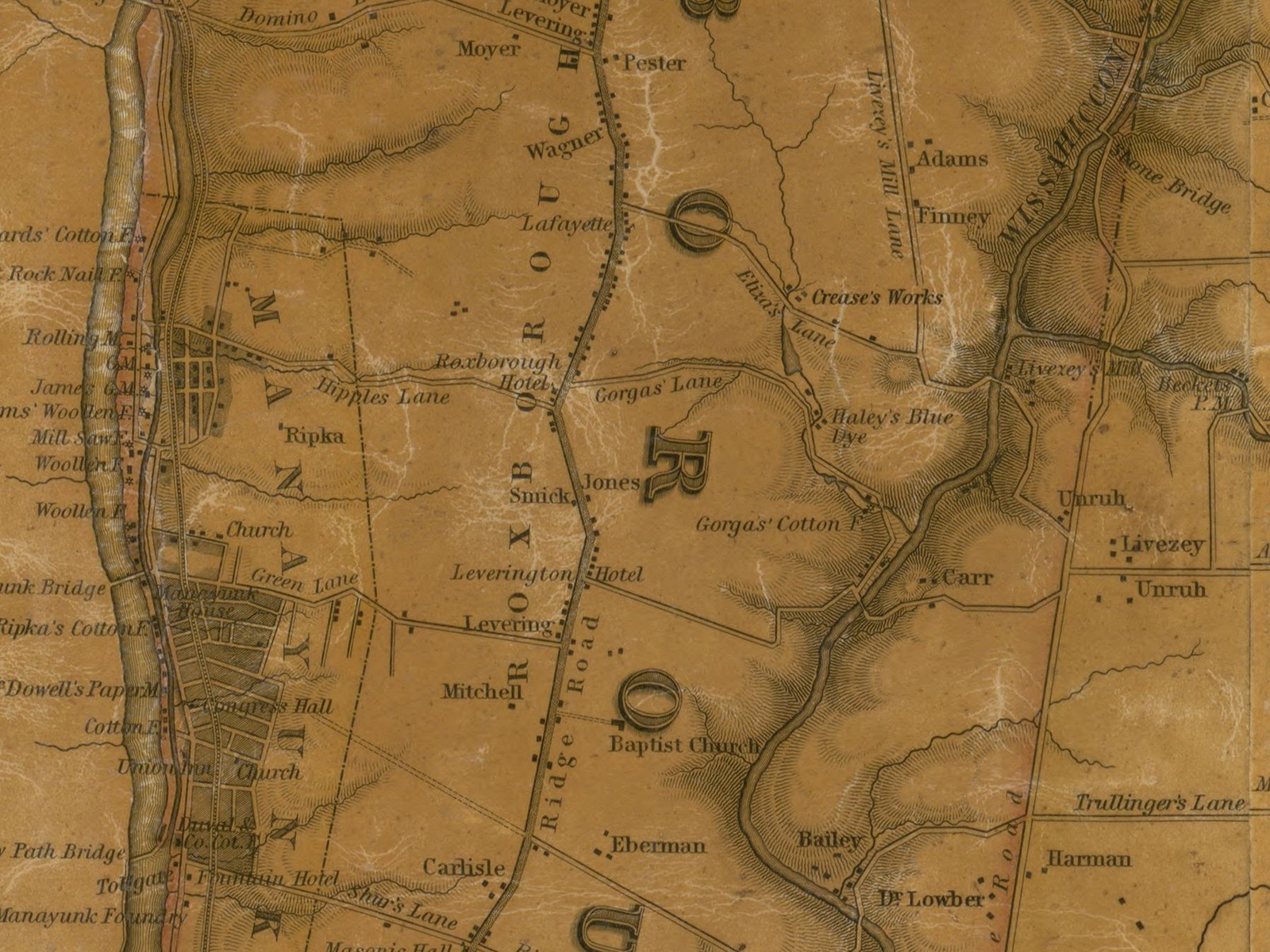
No picture of the buildings survives: no photograph or survey drawing of the works was found in anything read. The old maps name the seat but do not draw it; the one image on this page is a map detail, printed as a map, not a portrait of the mill.
Fixed by the records
Four witnesses fix the seat. The lawsuit over the dam — Levezey v. Gorgas, reported at 4 Dallas 61 — puts the Gorgas grist mill on the creek below the Livezeys’ mill, and the Gorgas dam is the suit’s subject. A situated list of 1779 puts John Gorgas’s grist mill and Benjamin Gorgas’s oil mill ninth and tenth, immediately below Thomas Livezey’s grist mill, eleventh. The maps agree: Ellet’s map of 1843 names a “Gorgas Cotton Factory” where Gorgas Lane meets the creek, and Barnes’s of 1855 still names “Gorgas’ Factory” above Levering’s Lane — today’s Leverington Avenue. And the lane keeps a witness: its little stream was still called “Oil Mill Run” when Brandt walked it in 1927.
Two brothers, two mills
The Roxborough tax lists show how the seat was divided between the two brothers who held it. In 1780 Benjamin Gorgas is entered as “Oylmiller,” in 1781 as “Oil Miller,” while his brother John is the plain “Miller”: John ran the grist mill, Benjamin the oil mill.
Then the brothers changed places — or divided the seat again. By 1785 Benjamin holds “1 Grist Mill” and John the “Oyl Mill”; John still holds the oil mill in 1786, when Benjamin holds half the grist mill and Jacob Gorgas the other half. In 1789 Benjamin holds the whole grist mill again, on 72 acres. The exchange is written nowhere but in these tax lines.
Which Benjamin the miller was, the record leaves open: the family held more than one — an uncle’s generation and a nephew’s — and the evidence runs toward the nephew without settling it. It is carried here as open, as the project’s Benjamin Gorgas biography carries it.
The work of the seat
The grist mill did merchant and country work both — the words are the seat’s own, from its 1798 sale advertisement: grinding grain for the market, and the neighbours’ grain for the neighbours. The oil mill pressed oil from seed; which seed, no record read names. Benjamin Gorgas is the only oil miller the valley’s records name, and the trade stands on this seat alone.
The tax lines price the seat: the grist mill at 800 in 1785, on a line with 60 acres and two dwellings totalling £1,310; the oil mill’s line at 575 in 1781; the grist mill at 450 by 1789.
The dam war
The seat’s water was fought over in the 1790s. The Livezeys, who had held their mill at Glen Fern since 1790, charged that the Gorgases had raised their dam, penned the water back, and broke the Livezey works. The case went to four referees — men appointed to settle it outside a courtroom — and their award was exact. It fixed the lawful height of the Gorgas dam by “the bottom of the hole bored in a certain rock” on the creek’s north-east side. It allowed the Livezeys, after notice and a freeholders’ view, to enter and pull the dam down themselves if it were raised higher. And it charged the mill’s holders £50, and £10 yearly, for the privilege of the dam.
The Supreme Court confirmed the award in 1796. On January 17, 1800, the High Court of Errors and Appeals reversed it, holding the referees had gone beyond the question put to them. The report names the losing side only as “Gorgas et al.” — Benjamin’s own place among the defendants is probable, not proven. How the two seats shared the water after 1800, no record read says.
Sold out of the name
On October 10, 1798, Claypoole’s American Daily Advertiser offered “a valuable Merchant, Country and Oil Mill, known by the name of Gorgas’s Mill; situate in Roxborough township… on Wissahickon creek,” with 25 acres — the combined plant, advertised whole. By January 1800 the name was already past tense: advertisements for the Rever plantation bounded their land by “Wisse’s or late Gorgas’s mill.” Who Wisse was, nothing else read says; he is printed as the advertisement gives him, and not merged with the Wise family of the paper mills up the creek at Wise’s Mill Road — a like name is not the same man.
The name did not leave the ground at once: Hotchkin’s history of the county (1889), as carried in the project files, says a John Gorgas of the next generation “ran the old mill” in Roxborough, and no dates or figures go with the line in anything read.
The cotton factory
By 1843 the seat had changed trades. Ellet’s map names it the Gorgas Cotton Factory, and Barnes’s map still names it Gorgas’ Factory in 1855. The name on the maps is the place’s, not a proprietor’s: who ran the cotton years, nothing read says.
The dyers
The seat’s last working chapter belongs to dyers. Cyrus Carmany found work in a Roxborough dye works by 1868. The census of 1880 shows Cyrus, and his sons John and Edmund, employed at the dye works, the family at 366 Green Lane. The Philadelphia directory of 1886 puts John H. Carmany on Gorgas Lane near the Wissahickon, where Cyrus and James Boone were partners — the firm of Carmany & Boone.
One caution belongs here. The Camden history behind the dyers’ story fixes them to Gorgas Lane, not to this building. Haley’s Dye Works stood on the same lane. Their placement on this seat is the one the project files carry; the other possibility stands beside it, not hidden.
In 1887 Cyrus Carmany bought a site in Camden and took the business across the river, trading there as the Wissahickon Dye Works. That December the Camden plant burned, and the Trenton Evening Times reported that “Mr. Carmany had but recently removed his business from a mill on the Wissahickon creek, and employed sixteen hands.” The sixteen hands are the business’s as it left the creek, printed at that grade.
The end
No taking, sale, fire, or demolition record naming this seat was found in anything read. When the Fairmount Park Commission began acquiring the valley’s mill sites in 1868, the list Gibson’s Workshop of the World gives does not name a Gorgas mill. The ground lay at the park’s edge, and its end was later and quieter than the taken mills’.
About 1872 the city still mapped the seat: the Streets Department plan of the Sixteenth Section, bounded by Gorgas Lane and Leverington Avenue, shows “ponds, factory and mill race” — the works still standing to be surveyed in the park’s first years. The 1917 revision lists building footprints only — no factory, no race. Between the surveys, the works leave the mapped record.
The last sighting is Brandt’s, in 1927: on Gorgas Lane “one soon sees on the left the remains of the ‘Haunted Mill,’ burned down, it is said, seventeen times.” The seventeen burnings are the lane’s legend, printed here as legend — not as this mill’s fire history, for which no record was read.
Three records that might say more stand as permanent gaps, outside this project’s online reach: the 1850 and 1860 manufactures schedules for the 21st Ward — the cotton factory’s figures, if any were returned; the deed books behind the sale of 1798–1800; and a 1949 typescript on the valley’s mills, kept on paper at the Free Library. What remains is the lane itself, and the little run beside it, still keeping the oil mill’s name.
Timeline
| Year | Event | Source |
|---|---|---|
| 1779 | Jones’s list: John Gorgas’s grist mill (9) and Benjamin Gorgas’s oil mill (10), just below Thomas Livezey’s grist mill (11) | Jones, The Levering Family (1858), p. 187, as quoted |
| 1780 | Benjamin taxed as “Oylmiller”; John as the plain “Miller” | Roxborough tax lines, via the Benjamin Gorgas dossier |
| 1781 | Benjamin “Oil Miller”; the oil mill’s line valued 575 | Roxborough tax lines |
| 1785 | The brothers have swapped: Benjamin holds 1 Grist Mill (800); John holds the Oyl Mill | Roxborough tax lines |
| 1786 | Benjamin holds ½ Grist Mill (400) and Jacob Gorgas the other half; John still holds the Oyl Mill | Roxborough tax lines |
| 1789 | Benjamin holds 1 Grist Mill (450) on 72 acres | Roxborough tax lines |
| 1796 | The dam award confirmed in the Supreme Court | Levezey v. Gorgas, 4 Dall. 61 |
| 1798 | “Gorgas’s Mill” — merchant, country, and oil mill on 25 acres — advertised whole, October 10 | Claypoole’s American Daily Advertiser |
| 1800 | The dam award reversed, January 17; land bounded by “Wisse’s or late Gorgas’s mill” | 4 Dall. 61; Claypoole’s |
| 1843 | Ellet’s map names the seat the Gorgas Cotton Factory | Ellet, Map of the County of Philadelphia, 1843 |
| 1855 | Barnes’s map still names it “Gorgas’ Factory” | Barnes, New Map of the Consolidated City, 1855 |
| 1868 | Cyrus Carmany at work in a Roxborough dye works | Camden history of John H. Carmany |
| c. 1872 | The city survey still maps “ponds, factory and mill race” on the seat | Streets Department plan 261-03, via GeoHistory |
| 1880 | Census: Cyrus Carmany and his sons John and Edmund at the dye works; the family at 366 Green Lane | 1880 census, via the Camden history |
| 1886 | Directory: John H. Carmany on Gorgas Lane; Carmany & Boone partners in the dye works | Philadelphia directory, via the Camden history |
| 1887 | The dyers remove to Camden as the Wissahickon Dye Works, sixteen hands | Trenton Evening Times, December 8, 1887 |
| 1917 | The revised city survey lists building footprints only — no factory, no race | Streets Department plan 261-07, via GeoHistory |
| 1927 | Brandt sees the remains of the “Haunted Mill” on Gorgas Lane | Brandt, The Wissahickon Valley (1927) |